
LANDARNA is now available through G-Cloud 15
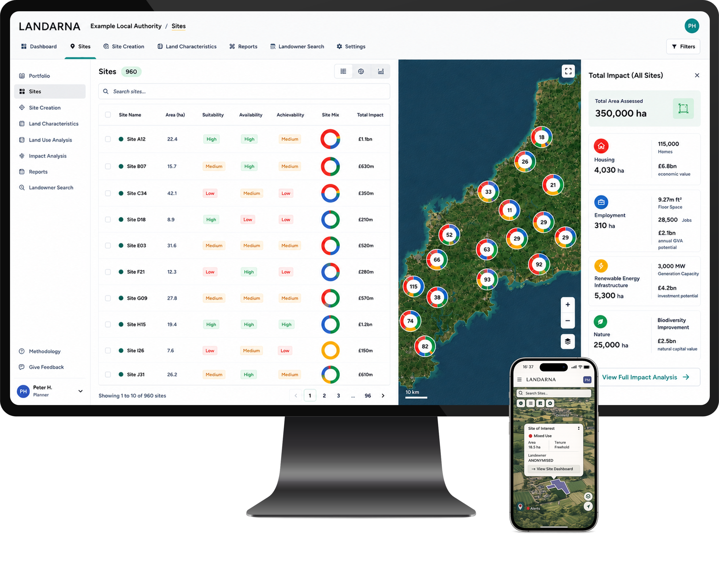
Landarna can be used across multiple device and teams to support regional planning and organisational land strategy.
Public-sector organisations can now procure LANDARNA through the UK Government’s G-Cloud 15 framework.
Developed by 3ADAPT, LANDARNA is a cloud-based geospatial decision-support platform that helps organisations make more informed, transparent and integrated decisions about land.
Our appointment to the framework provides eligible public-sector buyers with a more straightforward procurement route for accessing the platform, together with its onboarding, configuration and support services.
Better evidence for better land-use decisions
Decisions about land rarely involve a single objective.
A site that could support housing may also be important for food production, biodiversity, flood management, renewable energy or community access. At a wider scale, organisations need to understand how individual sites interact across an estate, programme, local authority area or region.
However, the evidence needed to support these decisions is often fragmented across datasets, maps, spreadsheets, teams and organisations.
LANDARNA brings this information together within a consistent and repeatable decision-support environment.
The platform allows organisations to:
combine national, organisational and licensed local geospatial datasets;
map land assets, constraints, commitments and opportunities;
undertake consistent site appraisal and automated scoring;
identify and prioritise potentially suitable locations;
compare alternative land-use and development scenarios;
assess environmental, social and economic impacts;
aggregate results across portfolios, programmes and regions;
record the evidence and assumptions behind decisions; and
communicate findings through interactive maps, dashboards and structured reporting.
From site appraisal to regional strategy
LANDARNA can support decision-making at multiple spatial and organisational scales. At a site level, it can provide consistent and audit-ready appraisal of land-use and development opportunities. At a portfolio, programme or regional level, it can support scenario testing, strategic prioritisation and collaboration between teams and organisations.
Applications include:
Local Plan making, including evidence development, Call for Sites processes, site assessment and options appraisal;
Spatial Development Strategies, including strategic and cross-boundary analysis of housing, employment, infrastructure, nature and energy needs;
estate-wide strategies, helping public bodies understand the constraints, opportunities and potential outcomes associated with their land portfolios;
programme-level decision-making, enabling multiple sites and interventions to be assessed, compared and prioritised consistently;
public-estate optimisation and asset management;
renewable energy and infrastructure opportunity assessment;
nature recovery and natural-capital programmes;
climate mitigation and adaptation planning;
land acquisition and disposal reviews; and
monitoring and reporting across portfolios of land-based interventions.
LANDARNA Advanced also supports multi-team and cross-departmental working, as well as controlled external sharing with partners and stakeholders. This enables evidence and portfolios to be shared across organisations using appropriate permission controls.
LANDARNA Core and LANDARNA Advanced
LANDARNA is offered through two subscription tiers to reflect different organisational needs, levels of functionality and scales of use.
LANDARNA Core
LANDARNA Core is suitable for smaller teams and organisations requiring consistent site appraisal and decision support using geospatial data.
It is typically used for site-level analysis, pilot projects and smaller land portfolios where collaboration is primarily internal.
Core includes:
site-level appraisal and automated scoring;
geospatial mapping and dashboards;
audit-ready and repeatable assessment workflows;
integration of national geospatial datasets;
assessment of site-level environmental, social and economic impacts;
up to two days of onboarding; and
portfolios of up to 1,000 sites or 10,000 hectares.
LANDARNA Advanced
LANDARNA Advanced is suitable for larger teams and organisations requiring portfolio-scale analysis, scenario testing and enhanced collaboration.
It supports strategic and cross-boundary applications, including Local Plans, Spatial Development Strategies, estate-wide strategies and programme-level decision-making.
Advanced includes all LANDARNA Core capabilities, together with:
integration of organisational and licensed local datasets;
site creation and land-use or development definition portals, including support for Call for Sites processes;
regional and portfolio-wide scenario testing;
multi-site, regional and portfolio-level assessment of environmental, social and economic impacts;
aggregated portfolio analytics and reporting;
multi-team and cross-departmental use;
controlled external sharing with partners, stakeholders and consultation participants;
up to five days of onboarding; and
portfolios of up to 10,000 sites or 100,000 hectares.
Both tiers are provided as secure, cloud-hosted Software as a Service and include hosting, maintenance and standard support. The appropriate tier, configuration and pricing are agreed at call-off and recorded within the relevant Order Form.
Supporting collaboration across teams and organisations
Strategic land-use decisions rarely sit within one department. Planning, estates, sustainability, climate, ecology, infrastructure, economic development and asset-management teams may all hold relevant evidence and have different requirements. LANDARNA provides a shared spatial framework through which these teams can assess options consistently, examine trade-offs and understand the combined implications of different land-use decisions. Where wider collaboration is required, LANDARNA Advanced can also support controlled sharing with delivery partners, neighbouring authorities, consultants and other stakeholders.
Phil Hampshire, Director and Co-founder of 3ADAPT, said:
“LANDARNA has been developed to connect decisions made at individual sites with the wider strategies and programmes they contribute to. Whether an organisation is preparing a Local Plan or Spatial Development Strategy, reviewing a public estate or prioritising a portfolio of projects, the platform provides a consistent way to bring evidence together, compare options and understand their environmental, social and economic implications.”
What G-Cloud 15 means for buyers
LANDARNA’s inclusion on G-Cloud 15 provides public-sector buyers with a defined route through which to procure the platform and its associated support.
Published service information, pricing principles and contractual terms can help organisations move more efficiently from identifying a need to deploying a practical decision-support solution.
The platform is supported by 3ADAPT’s multidisciplinary team, combining expertise in sustainability, ecology, climate change, carbon, planning, research, stakeholder engagement and decision analysis.
Work with us
Read more about LANDARNA’s capabilities and applications, or contact us to arrange an introductory demonstration.
You can also read the 3ADAPT G-Cloud 15 announcement to learn more about the strategic, technical and implementation support available alongside the platform.